
REPORT OF THE FIRST RECOGNITION TRIP
OF AN ASTRONOMICAL SITE SURVEY IN
ARGENTINE NORTHWEST.
Pablo Recabarren & Mirta Mosconi
Grupo IATE, Observatorio Astronómico de Córdoba, Argentina.
1. Introduction.
In January of 2002, the group made up of Riccardo Giovanelli, Martha Haynes, Diego García Lambas, Hernán Muriel, Mirta Mosconi and Pablo Recabarren spent some days in the Northern-West region of Argentine, in order to study the astronomical potential of the zone. This is the first phase of a site survey work developed by astronomers of the IATE group of the Observatorio Astronómico de Córdoba in collaboration with Cornell University and with ESO.
The main target of the present work is to locate candidate places to install astronomical facilities. In this sense, we describe topographic and infrastructure aspects of the N-W region of Argentine, located between 23º 15' and 24º 30' of South latitude and 65º 30' and 67º 30' of the West longitude, reaching the Chilean border, known as "La Puna".
2. Main Cities and Towns.
If has been explored the West region of the Argentinian provinces of Jujuy and Salta. The principal cities are the respective provincial capitals, which possess the facilities and infrastructure of the medium size cities: airports, universities, communications, electric power stations, hotels, car and truck rentals, shopping centers, etc. To compare with, these cities are bigger than the Chilean cities of Calama and Antofagasta.
Salta City
The most important town in the explored region is San Antonio de los Cobres (SAC), which counts on about 3200 inhabitants. This city used to be a big mining development center ten years ago. The present Argentinian recession has contributed to the decrease of the infrastructure resources.
SAC (3800 m ) can be reached from Salta (1200 m ) going to the West by a paved road (160 km) through the Quebrada del Río Toro, where a Gendarmerie detachment and an Army regiment are passed. While Salta is located in green, humid and subtropical climate of the Valle de Lerma, SAC is in the Puna, with a cold and dry climate (between April and September –winter seasons- the average precipitation is less than 5 mm).

San Antonio de los Cobres
SAC is the main train station of the railway from Salt to Socompa, on the Chilean border which runs across of the Pocitos and Arizaro salt flats and several small towns like Olacapato, Cauchari, Pocitos, Caipe and Socompa. The train is the main type of transportation in this sector of La Puna.
SAC counts on minor guesthouses that are very modest, and a small although cozy hotel (Hotel de las Nubes) with approximately 20 rooms (and full-board if requested). This last accommodation can be used as the operation base of the region.
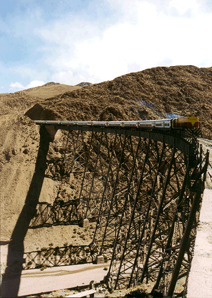
Train crossing "La Polvorilla" railway bridge near SAC.
Other main town in the north of the area is Susques. It is a small town with 2800 inhabitants, has electricity services and is the base of the company (Roggio) that is paving the road to the Paso de Jama, so they possess a lot of trucks and machines. If is the second important city after SAC in the region. Susques could be used as operation base, too.
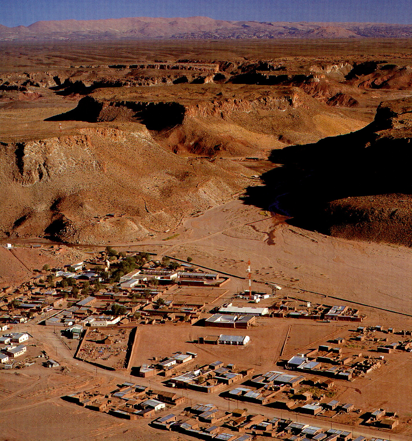
Susques
3. Travelling.
The Nevado the Acay (5950 m ) is placed toward the S-SE. On the West, following the national route 51 that finally reaches the Paso de Sico (Chilean border), the point called Alto Chorrillo (4580 m ) is passed by at 30 km from SAC. Two small towns are reached, Olacapato Grande (4050 m ) and Caucharí (3975 m) after passing by the descending valley of the Tocomar (4340 m ) in the direction W-NW, till the Southern end of the Salar de Caucharí, which has an average height of around 4000 m throughout the salar.

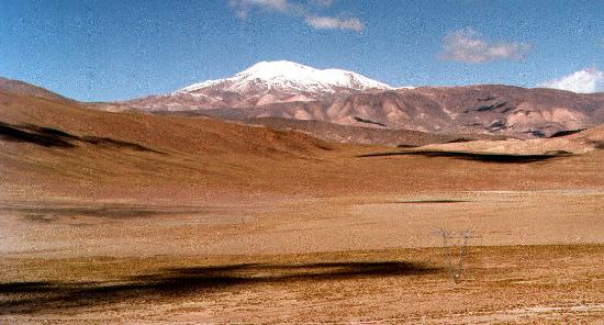
Nevado de Acay
The valle of Tocomar exhibits big plains of about 10 km width, both sides of the road, and there are mountains of around 5000-5500 m height toward the S-W and N-E. There are also springs (manantials), and a lot of animals (llamas, guanacos). The railway track is located North, and there is also a high voltage distribution line, with several roads that converge to the towers.
Near Alto Chorrillo to Tocomar. The Nevado de Acay is in the back.
Between Tocomar and Olacapato there is a place called Pastos Amarillos which is a big flat valley of 8 Km long and 3 Km wide at around 4200 m height.

Pastos Amarillos
Caucharí is an abandoned town. Olacapato is a small one with around 200 inhabitants. It has electricity services and a very modest guesthouse. There is an old train station with abandoned installations that seem to be robust and in good conditions the train used to stop in this town when goes to Socompa, although today nobody works in the station.
The Sierra del Nevado de Queva (6130 m ) is located S-SW of SAC, and it is surrounded by a dirt road that is in very good condition that passes by Caucharí, Laguna Seca, Pocitos, Santa Rosa de los Pastos Grandes, and the Abra del Gallo (4720 m ), the highest point of the circuit near SAC. The road is winding and there are some streams along it. It is a very uneven piece of land, although there are some plains of about 1 km size.
There are 3 different provincial roads that leave from Pocitos: route 129 goes to E-NE, to Santa Rosa de los Pastos Grandes, Abra del Gallo and SAC; route 17 goes to Antofagasta de la Sierra (Catamarca Province) toward the South, near the Volcán Galán (5912 m ) and route 27 that ends in the frontier, in the Paso de Socompa, near to the volcano of the same name (6031 m ), passing by the Salar de Arizaro and the localities of the Tolar Grande (3526 m ) and Taca Taca. This salar has a large expanse limited to the N-W by peaks of around 5500-6000 m height, and has an average height of 3500 m.

Salar de Arizaro
The road and the railway run across Arizaro flat salt reaching the Chilean border in Socompa Station, near de Volcano of the same name. The railway goes to Antofagasta city, in Chile.

Volcán Socompa
From Caucharí toward the North-West, the road ends in the Paso de Sico (4130 m) passing by the Salar del Rincón (4011 m). The high voltage line described before, runs some kilometers away parallel to the road. This line provides the city of Antofagasta (Chile) with electricity. Toward the West, there are several peaks as the Cerro Rincón (5594 m) and Cerro Tultul (5267 m). The border post (3859 m) is 50 km far from Caucharí, and 10 km from the border. The private company Termoandes (the high voltage line owner) takes records about temperature and wind speed and direction. Toward the East of the border post, 16 km away is located Catua (4009 m) with around 400 inhabitants but it has less infrastructure than Olocapato.
From Caucharí to the North, there is a very bad dirt road in the West border of the Salar the Caucharí (3950 m ) that ends in a fork: it goes N-W to the Paso de Jama (the Chilean route on the other side is road surface and passes by San Pedro de Atacama), and N-E to the locality of Susques (3645 m). From this fork to the Paso de Jama (4425 m) there is a plain of a large expanse located in the South of the Trópico de Capricornio 4100 m. In the direction N-W it is located the Cerro Pili. From the fork there are 2 roads to go to Susques: one surrounds the Salina de Olaraz going North (around 3940 m ) and the other goes through this Salina in the direction N-E, and this last track is the most passable and travelled. On the West, near Susques (60 km away from the fork) there is a track that goes South (route 74) and joins the road to SAC.
From Susques the road connects to Purmamarca, in the Quebrada de Humahuaca, (130 km far and 2300 m ) passing by the Quebrada del Mal Paso (3780 m), Tres Pozos (3459 m), Salinas Grandes (3436 m and located 60 km away from Susques), the crossing of the national route 40 (that goes North to Abra Pampa and South to SAC), the mountain range of the Sierra del Chañi, finally descending by the Puerta de Lipán. The city of Jujuy is around 70 km from Purmamarca toward the South.

Quebrada de Humahuaca
4. Roadmap.

5. Conclusions.
We have found a large number of interesting sites, with potential both for optical and submm instruments. There was almost complete absence of wind, even at the highest points, and the weather looks pretty dry.
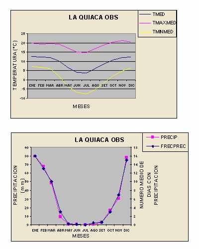
20 years average of temperature and precipitation measured in the weather station of La Quiaca (22º10’S–65º30’W), by the Servicio Meteorologico Nacional (www.meteonet.com.ar). The region described in the present document, 100 Km further than La quiaca, is drier, but we do not have records of it.
It is necessary to carry a survey work in the region, with seeing and weather monitoring, in order to complement with the satellite images reduction information in process at the present, in Cordoba.
The area described in this work has the problem of the seismic activity which decreases toward the south, then, the group will continue the survey in the Andes of the Catamarca and San Juan provinces.