Satellite Mega-Constellations
Simulations and more
O.Hainaut - ESO - 2020-03-15, upd. 2021-03-15: new OneWeb2 reduced
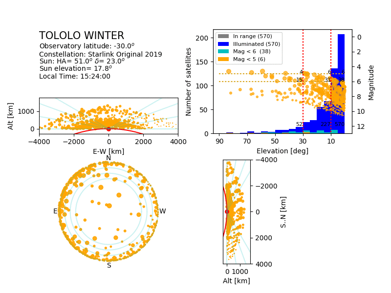
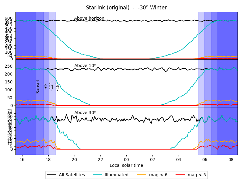
The following simulations evaluate the visibility of ~12000
Starlink original satellites (Generation 1) on the sub-constellations
listed in the table below (which is a slight simplification of the
announced actual orbital distribution). This constellation is the
original one, from the 2019 filings by Starlink. It is the same as
used by J.McDowell in his recent paper
(2020,
ApJL, 892, 2), and as "Model I" in
his Starlink
simulation pages.
In Apr.2020, Starlink announced a plan to to deploy the satellites
originally planned at altitudes 1100-1300km on lower orbits in the
540-570 range. The simulations below are performed using the original
constellation. A comparison with this new configuration --and others-- is given
below.
| Altitude [km] | Inclination [deg] | Planes | Satellites |
|---|
| 346 | 53 | 42 | 2547 |
| 341 | 48 | 42 | 2478 |
| 336 | 42 | 42 | 2493 |
| 550 | 53 | 72 | 1584 |
| 1110 | 54 | 32 | 1600 |
| 1130 | 74 | 16 | 400 |
| 1275 | 81 | 10 | 375 |
| 1325 | 70 | 12 | 450 |
Table 1: Original Starlink constellation.
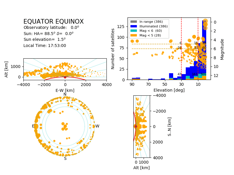
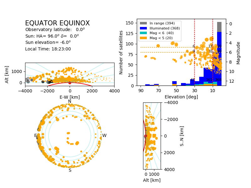
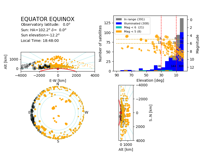
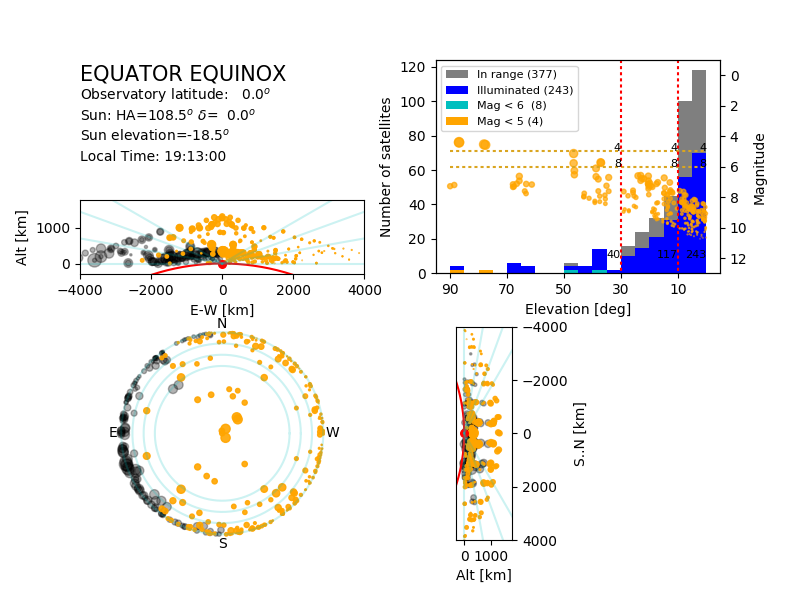
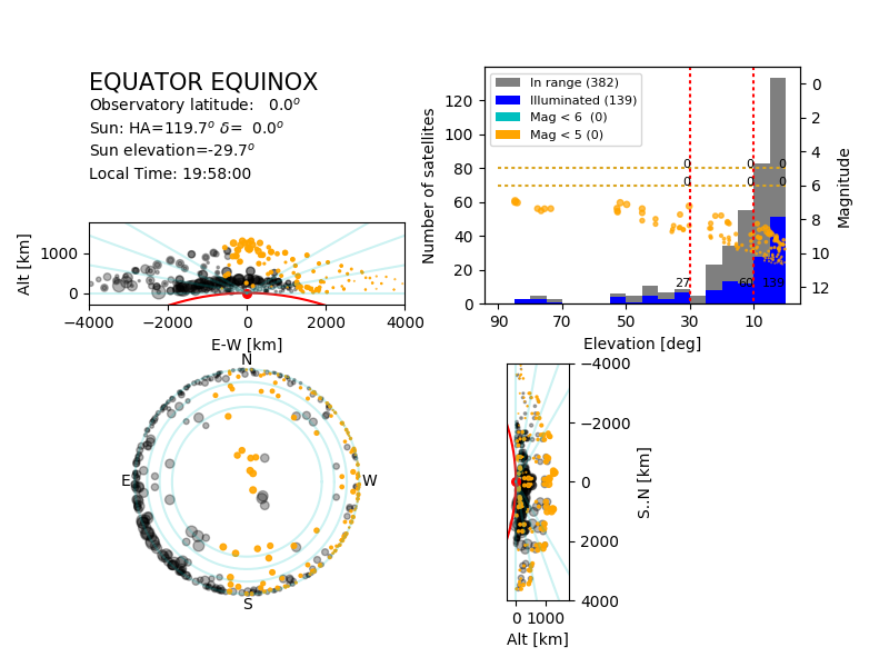
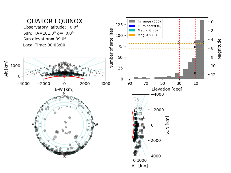
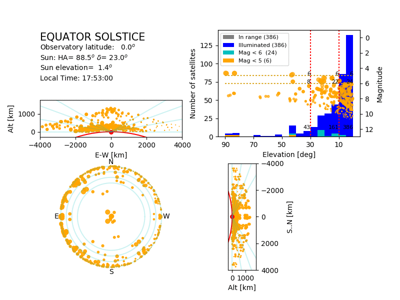
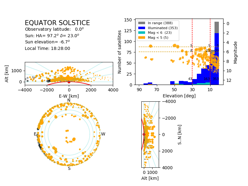
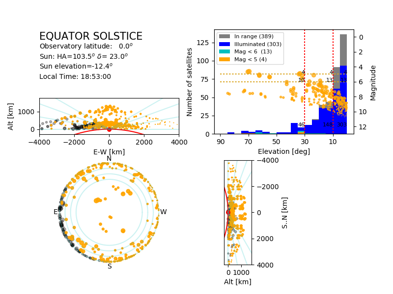
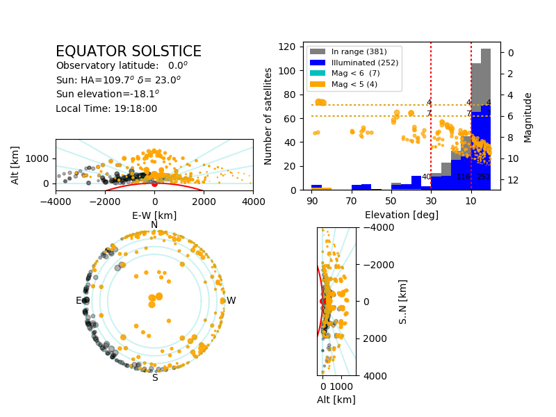
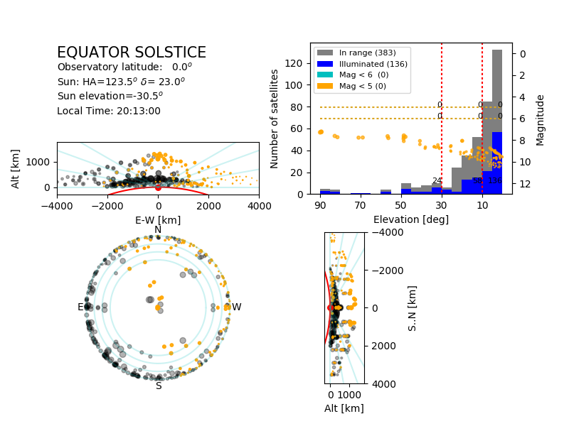
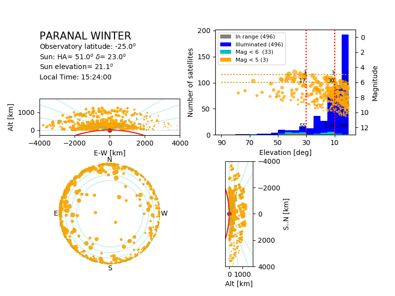
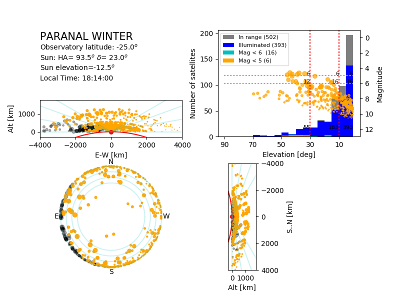
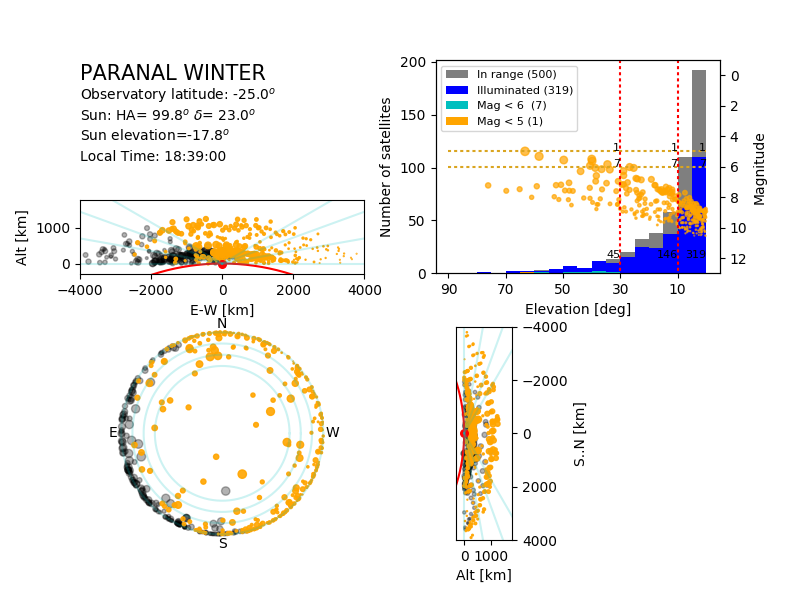
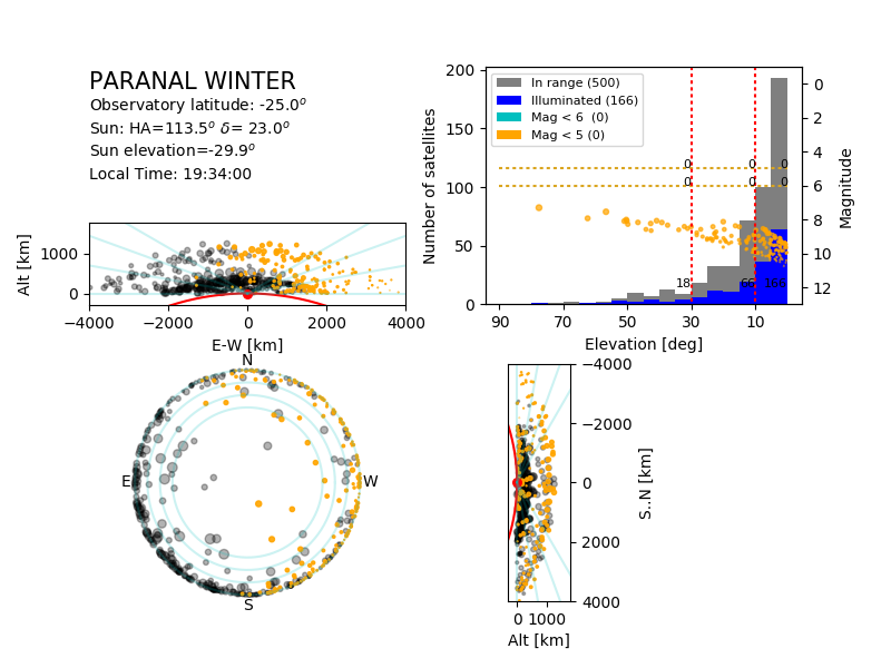
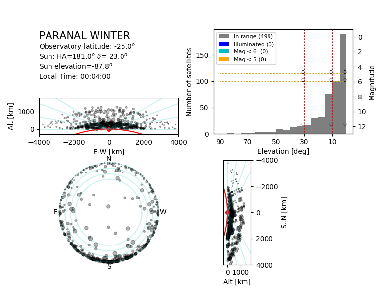
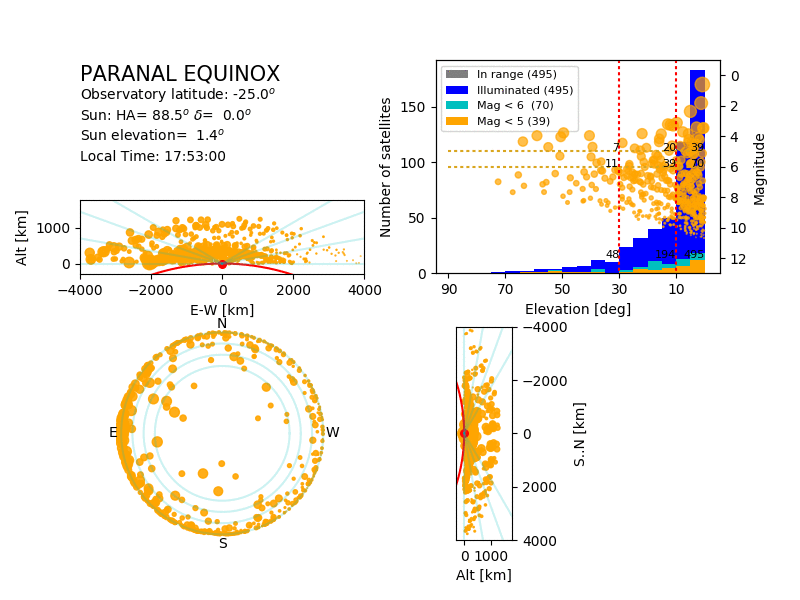
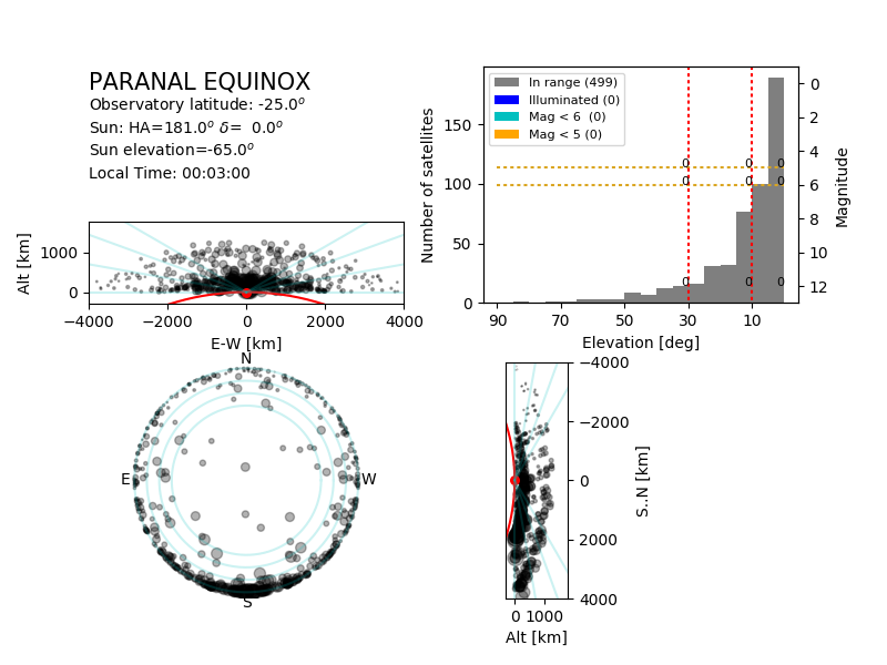
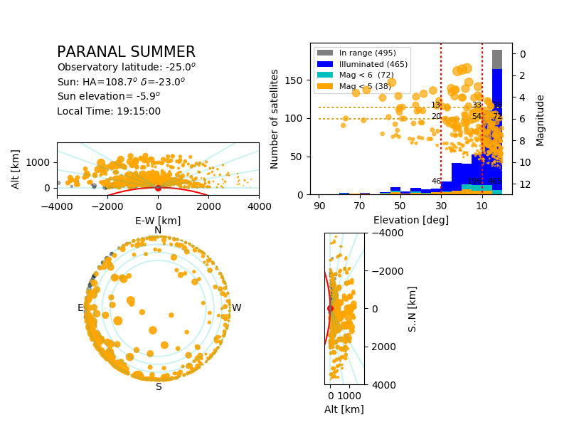
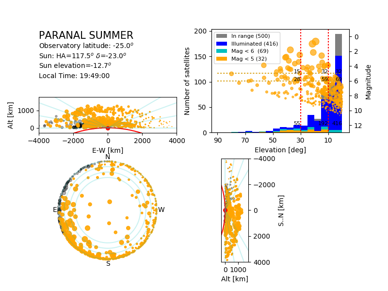
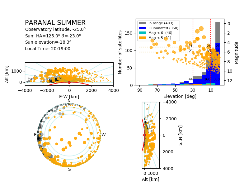
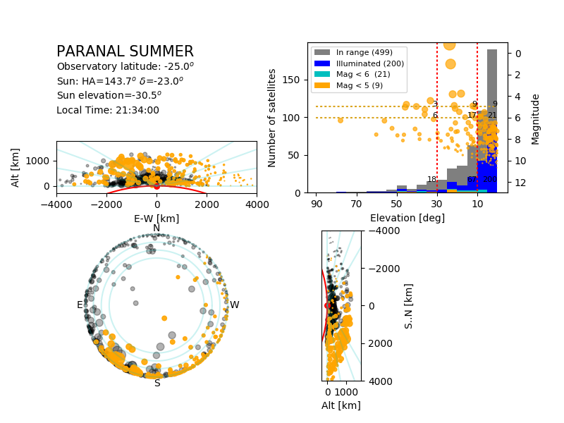
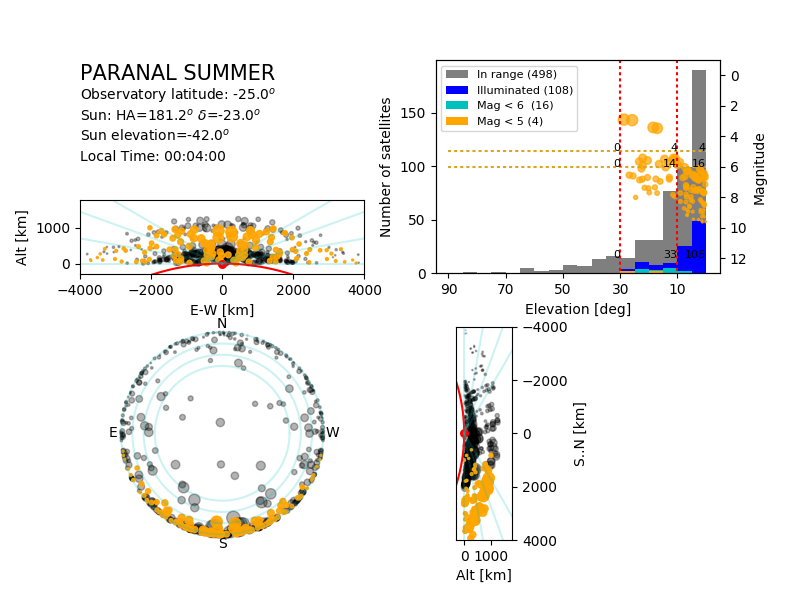
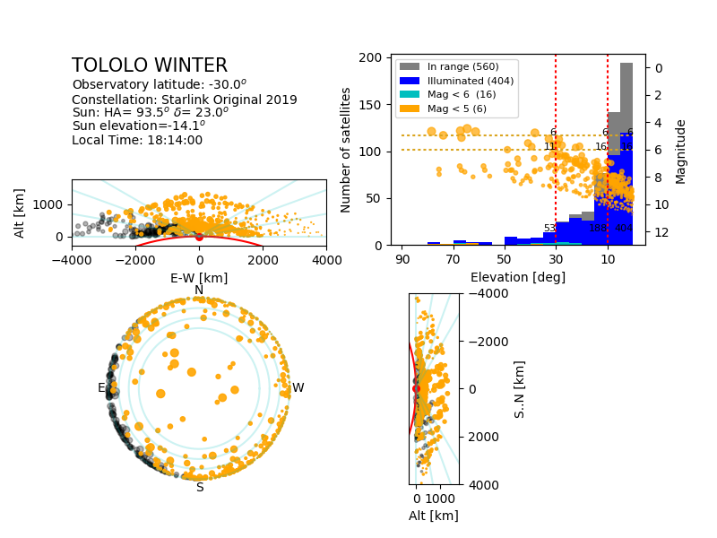
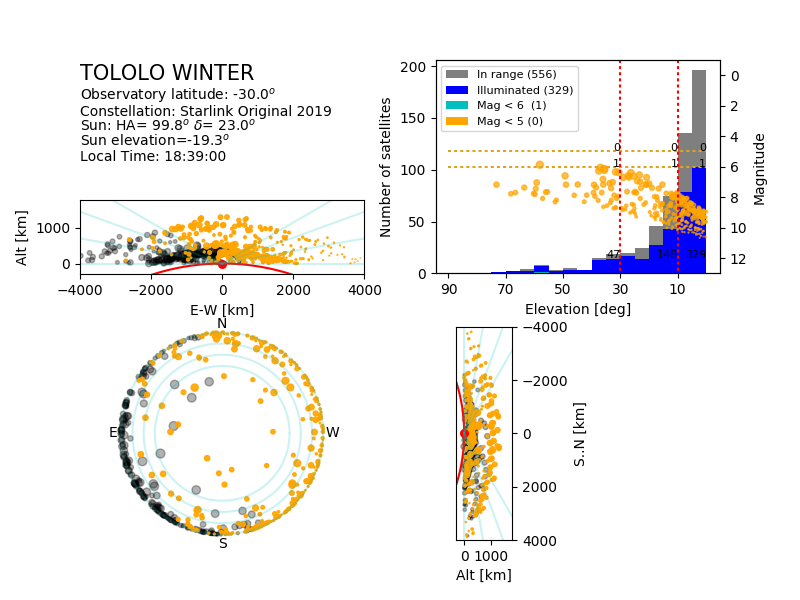
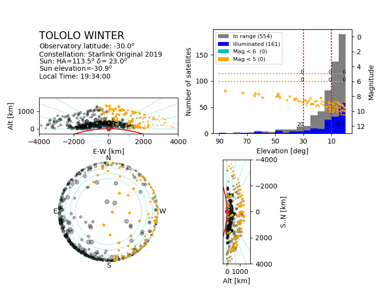
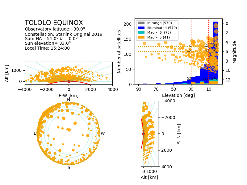
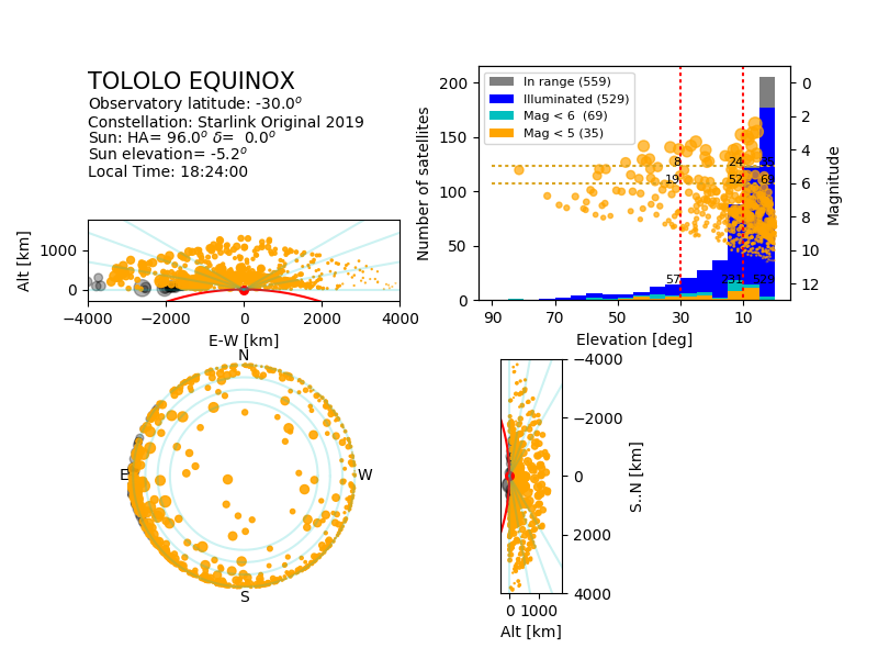
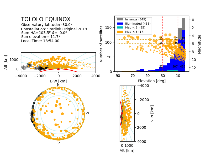
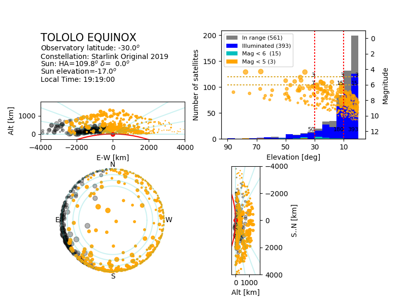
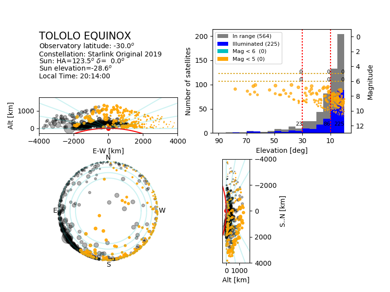
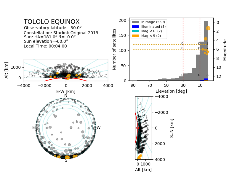
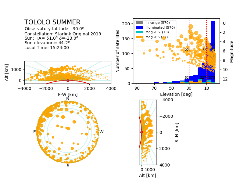
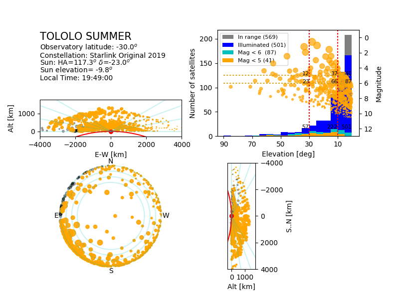
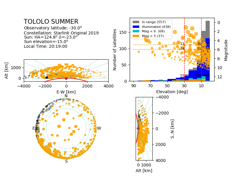
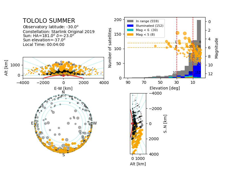
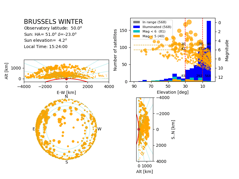
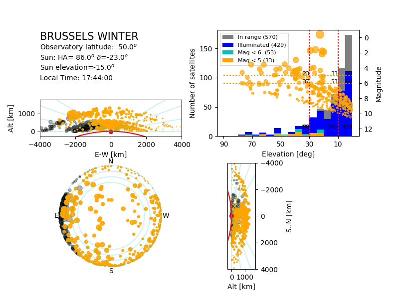
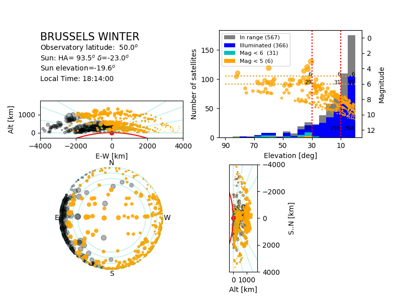
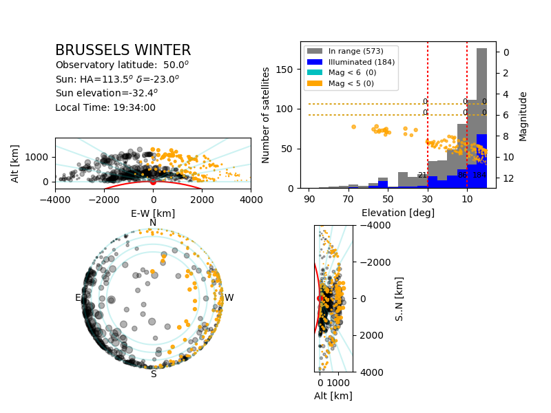
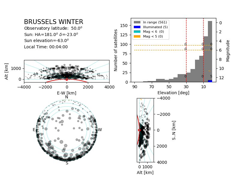
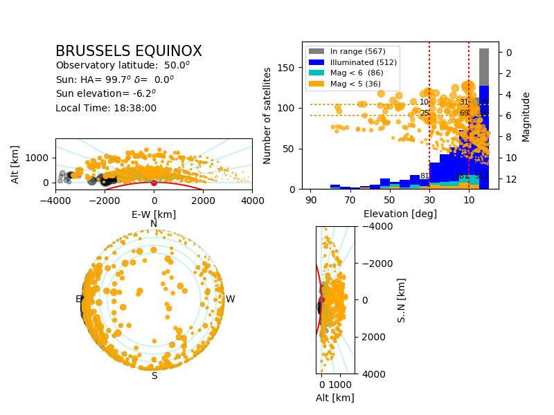
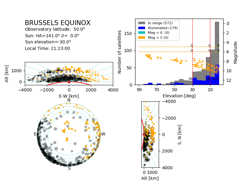
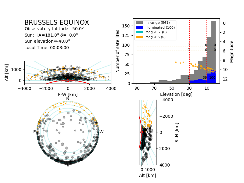
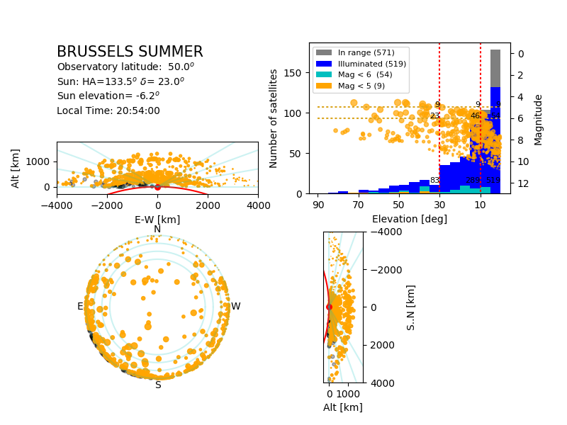
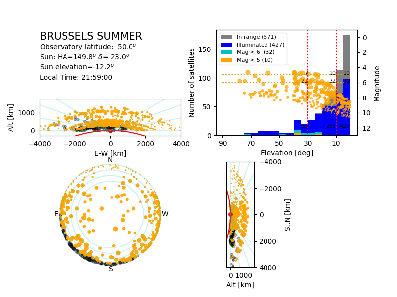
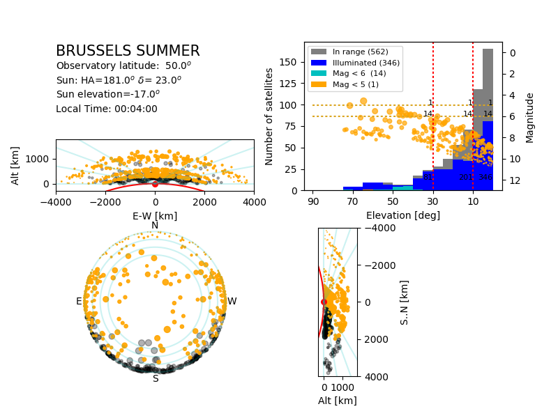
In the plots below,
- The illuminated satellites are in orange, those in the shadow of the Earth in black.
- The size of the symbol indicates the magnitude of the satellite.
For satellites in the shadow of the Earth (which are therefore not
illuminated and not visible), the size indicate the magnitude they would
have had if the Earth was transparent.
- The two side views show the constellation above the horizon; the
red line marks the surface of the Earth, the red dot the observatory.
The blue lines mark 10, 20 and 30deg elevation above the horizon.
- The sky view has circles marking 10, 20 and 30 degrees elevation above the horizon.
- The top-right plot shows the histogram of all satellites above
the horizon, as a function of the elevation: typically, about half
the satellites are in the band below 10deg elevation. The histogram
is subdivided for naked-eye satellites (mag <5), naked-eye
satellites in optimal conditions (mag<6), all illuminated
satellites, and all satellites in range. The plot also shows the
magnitude of the satellites as a function of their elevation. The
values listed in the plot indicate the number of satellites higher in
elevation and brigher than the position of the value.
- For illustration purpose, the animation show the motion of the satellites not including the rotation of the Earth. In real life, the whole constellation drifts westward by 15deg per hour.
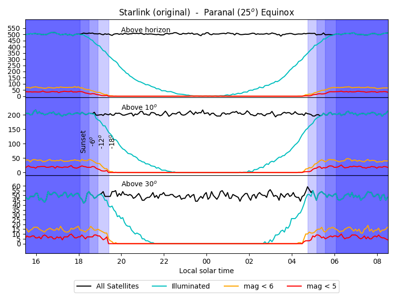
The plots are generated for solstices and equinox, for an equatorial observatory (0deg latitude), Paranal (25deg
lat. S) and Brussels (50deg lat. N.).
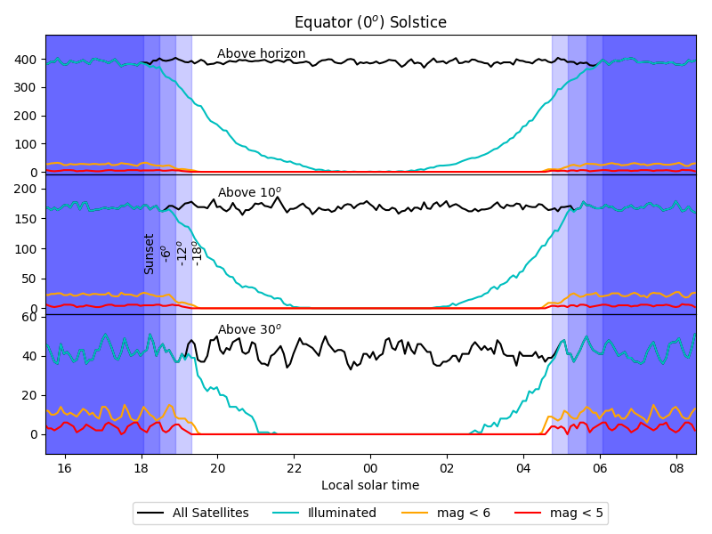
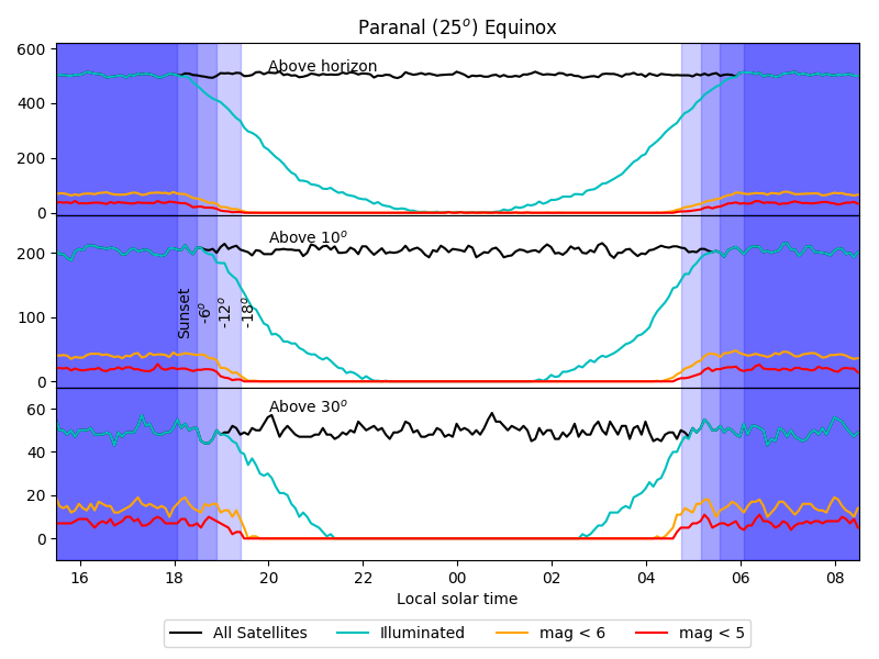
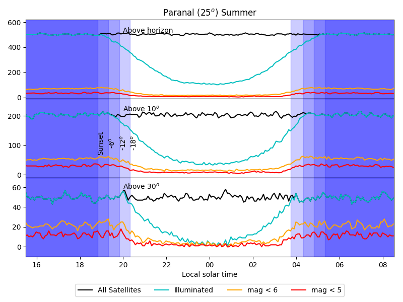
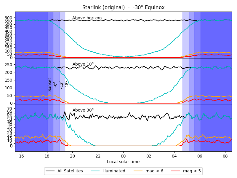
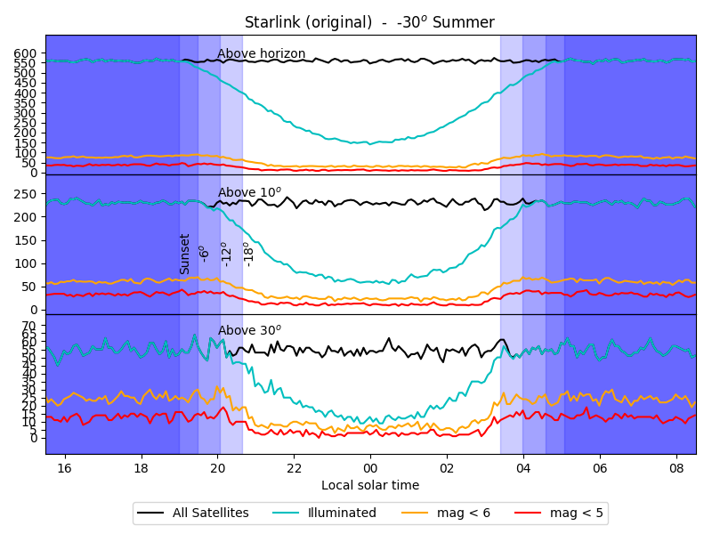
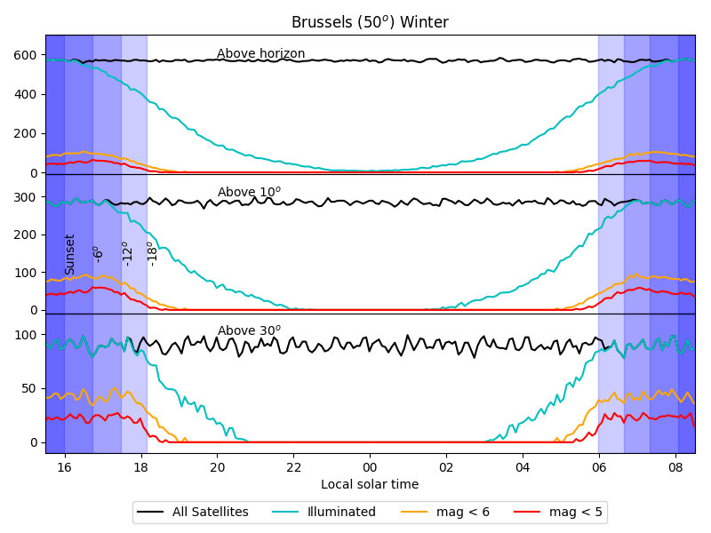
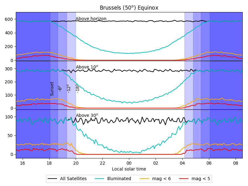
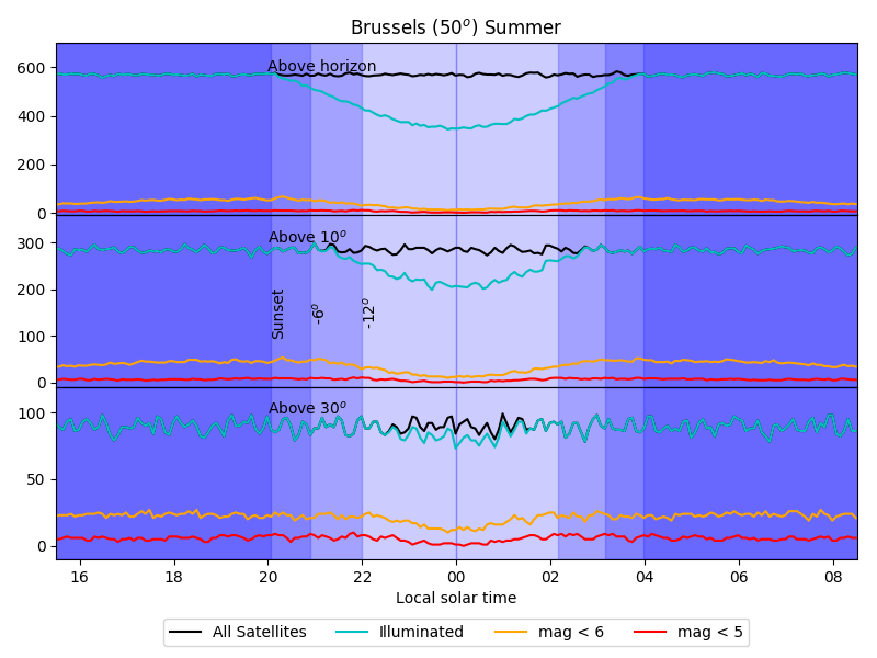
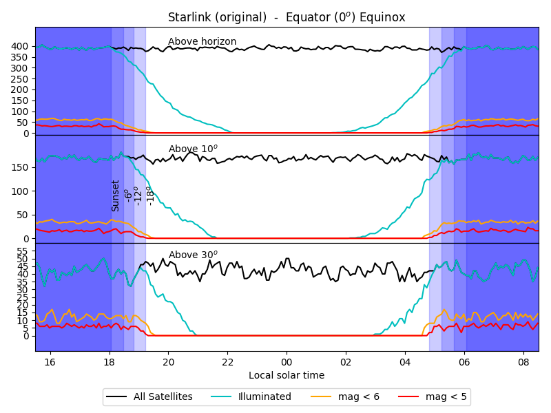
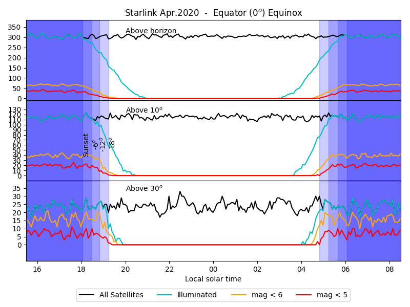
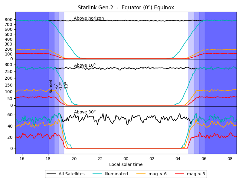
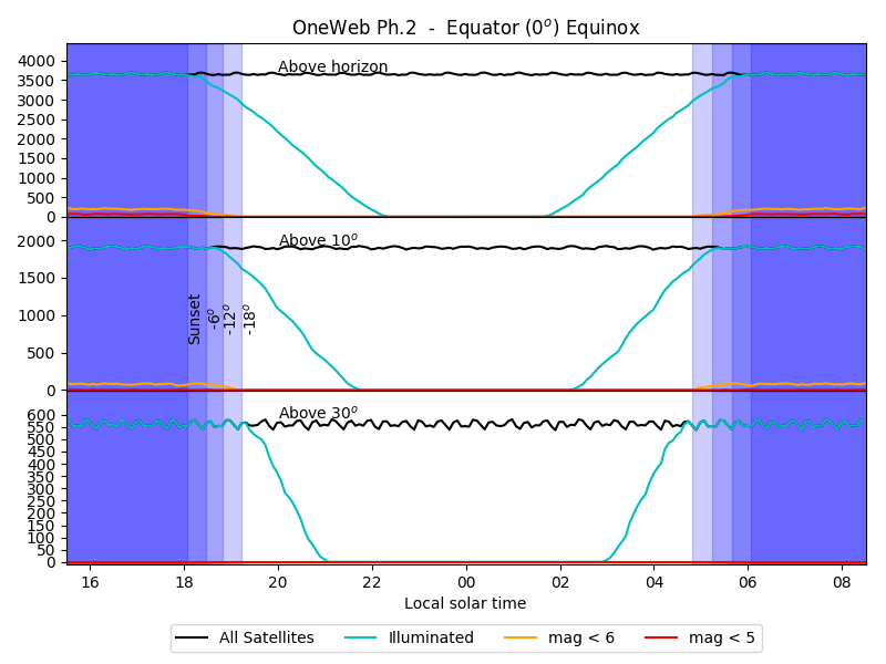
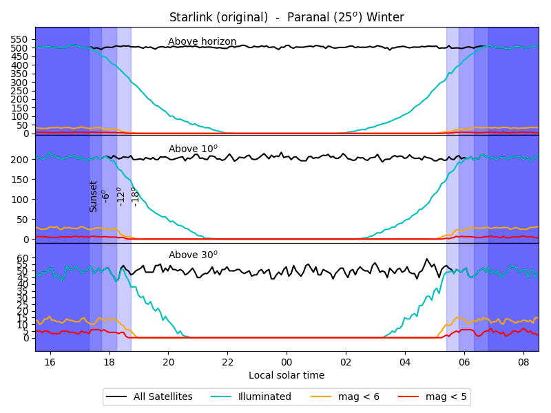
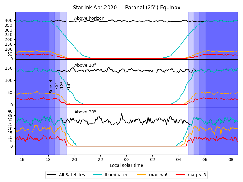
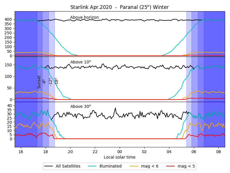
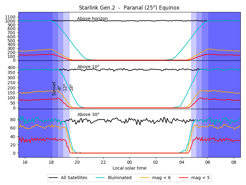
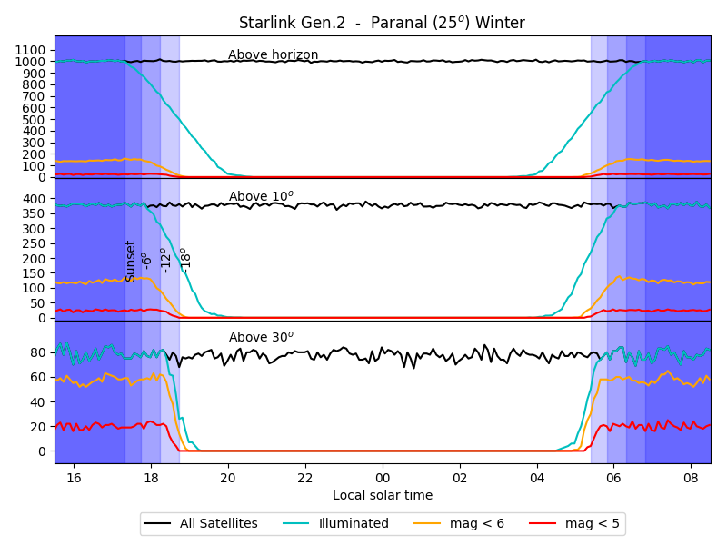
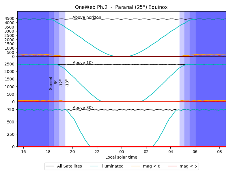
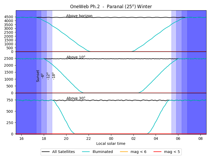
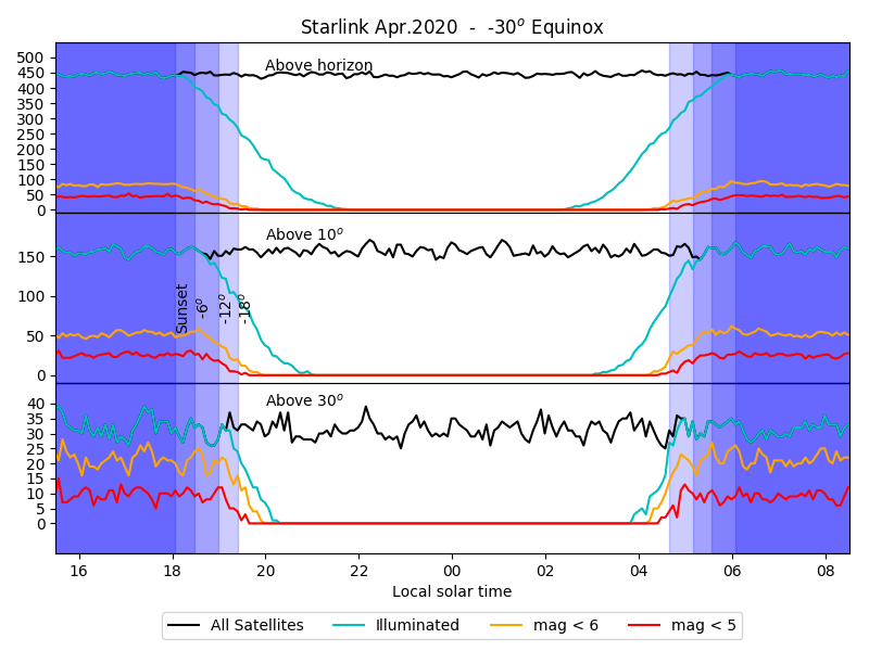
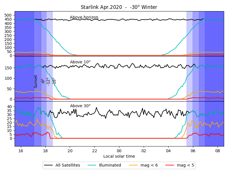
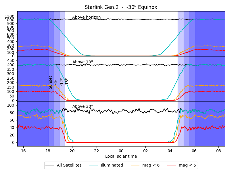
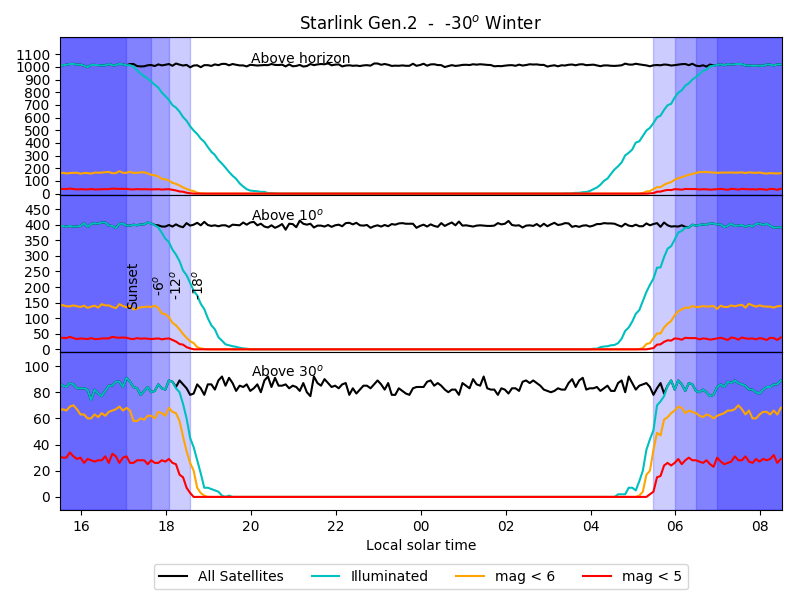
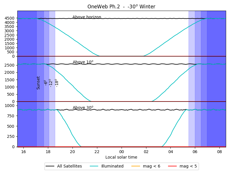
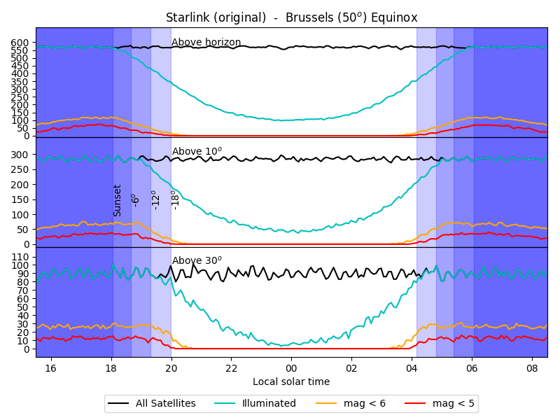
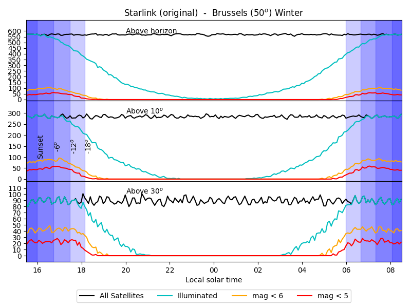
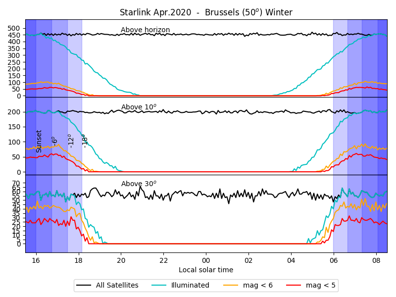
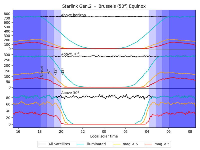
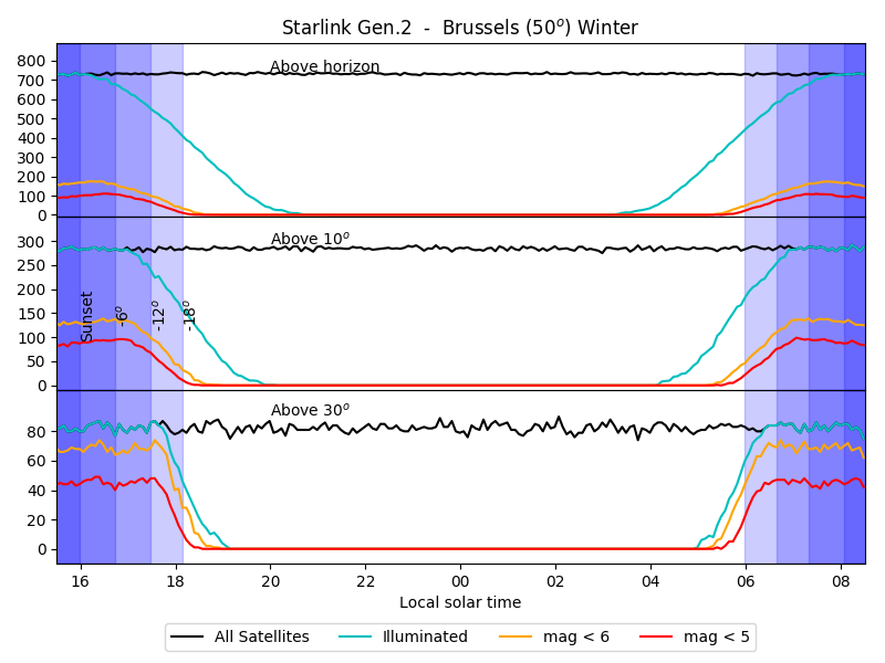
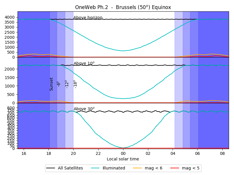
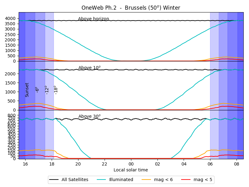
The summary plots show the number of satellites as a function of local time. The black curve is the number of satellites in the sky, cyan the number of illuminated satellites (of any magnitude), orange those brighter than mag 6, the red line those brighter than mag 5. The 3 plots show the number of satellites in the whole sky, above 10deg of elevation (for visual observations and astrophotography), and above 30deg (for telescopic observations).
Latitude = 0deg: Equator
Equinox

| Sun elevation:-6deg | -12deg | -18deg | -30deg | Midnight |
|---|
 |
 |
 |
 |
 |
Solstice
| Sun elevation:-6deg | -12deg | -18deg | -30deg | Midnight |
|---|
 |
 |
 |
 |
 |
Latitude = 25deg: Paranal
Winter
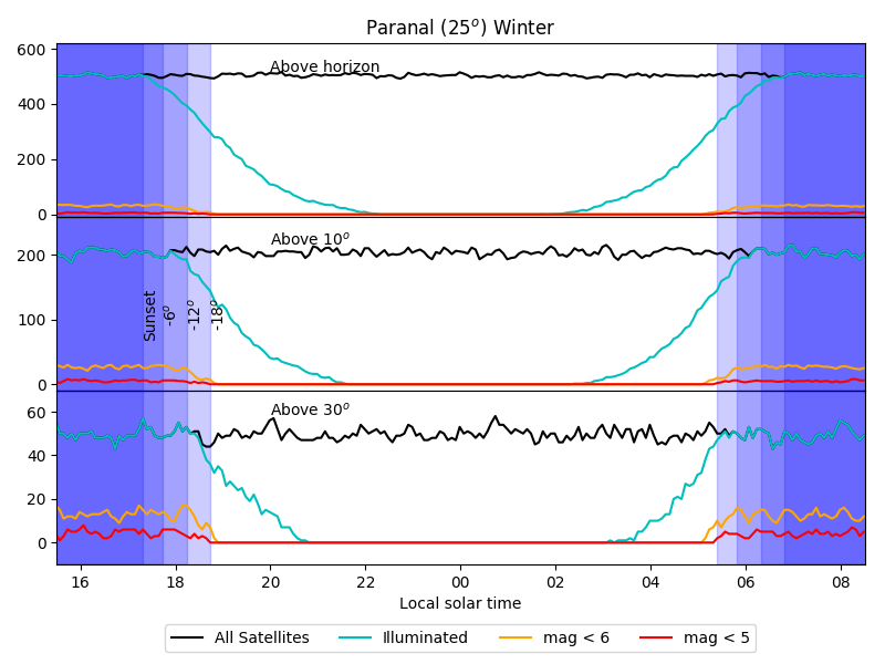
| Sun elevation:-6deg | -12deg | -18deg | -30deg | Midnight |
|---|
 |
 |
 |
 |
 |
Equinox
| Sun elevation: -6deg | -12deg | -18deg | -30deg | Midnight |
|---|
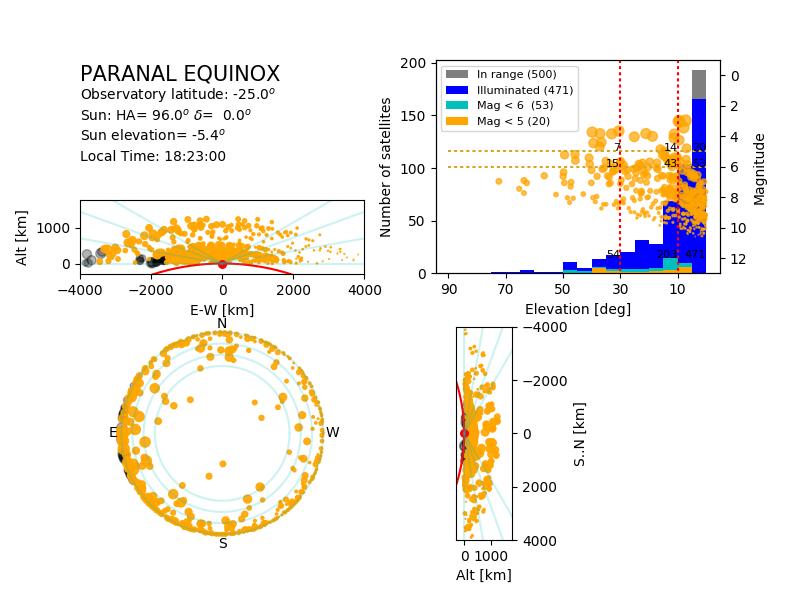 |
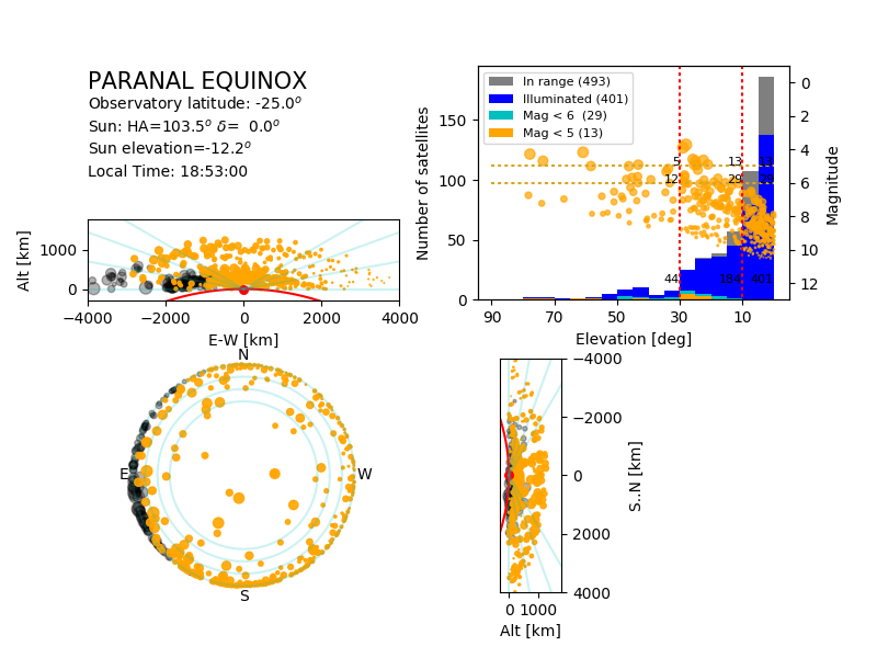 |
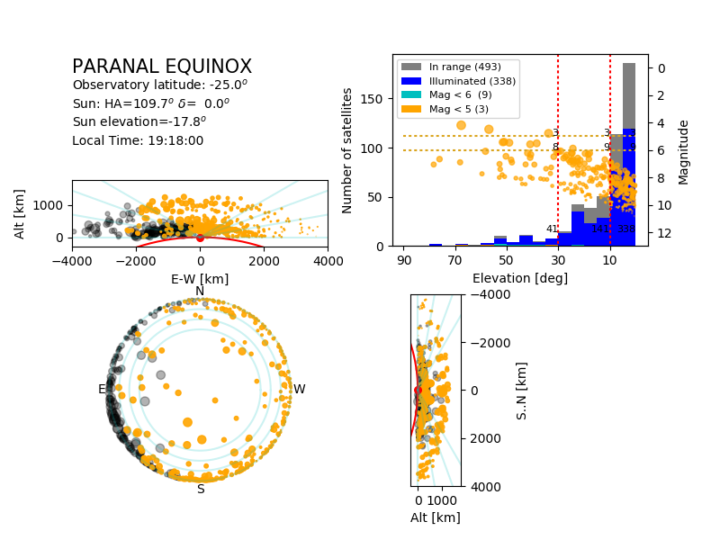 |
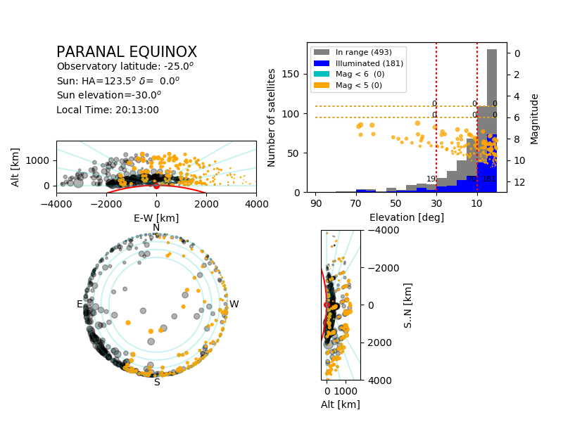 |
 |
Summer

| Sun elevation: -6deg | -12deg | -18deg | -30deg | Midnight
|
|---|
| 
| 
| 
| 
|
Latitude = 30deg: Tololo
Winter
| Sun elevation:-6deg | -12deg | -18deg | -30deg | Midnight |
|---|
 |
 |
 |
 |
 |
Equinox
| Sun elevation: -6deg | -12deg | -18deg | -30deg | Midnight |
|---|
 |
 |
 |
 |
 |
Summer
| Sun elevation: -6deg | -12deg | -18deg | -30deg | Midnight
|
|---|

| 
| 
| 
| 
|
Latitude = 50deg: Brussels
Winter
| Sun elevation: -6deg | -12deg | -18deg | -30deg | Midnight
|
|---|
| 
| 
| 
| 
|
Equinox

| Sun elevation: -6deg | -12deg | -18deg | -30deg | Midnight
|
|---|
| 
| 
| 
| 
|
Summer

| Sun elevation: -6deg | -12deg | -18deg | -30deg | Midnight
|
|---|
| 
| 
| -n/a-
|
|
Comparison between constellations
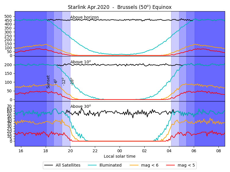
In April 2020, Starlink requested permission to deploy the ~2800 satellites originally foreseen for altitudes above 1000km to the 540 to 570 range, resulting in a modified constellation, whose parameters are listed in Table 2.
In May 2020, Starlink filed for another change to their constellation, resulting in the parameters listed in Table 3 (from JMcD Model III).
The comparision also includes the OneWeb constellation, Phase 2 (from May 2020 filing, with 50k satellites; from JMcD Model IV), listed in Table 4.
| Altitude [km] | Inclination [deg] | Planes | Satellites |
|---|
| 346 | 53 | 42 | 2547 |
| 341 | 48 | 42 | 2478 |
| 336 | 42 | 42 | 2493 |
| 550 | 53 | 72 | 1584 |
| 1110 | 54 | 32 | 1600 |
| 1130 | 74 | 16 | 400 |
| 1275 | 81 | 10 | 375 |
| 1325 | 70 | 12 | 450 |
Table 1: Original Starlink constellation (similar to JMcD's Model I). 12k Sat.
| Altitude [km] | Inclination [deg] | Planes | Satellites |
|---|
| 346 | 53 | 42 | 2547 |
| 341 | 48 | 42 | 2478 |
| 336 | 42 | 42 | 2493 |
| 550 | 53 | 72 | 1584 |
| 540 | 54 | 32 | 1600 |
| 545 | 74 | 16 | 400 |
| 560 | 81 | 10 | 375 |
| 570 | 70 | 12 | 450 |
Table 2: Rev.2020 of Starlink constellation. 12k Sat.
| Altitude [km] | Inclination [deg] | Planes | Satellites |
|---|
| 328 | 30 | 84 | 7178 |
| 334 | 40 | 84 | 7178 |
| 345 | 53 | 84 | 7178 |
| 373 | 75 | 20 | 1998 |
| 499 | 53 | 40 | 4000 |
| 604 | 148 | 12 | 144 |
| 614 | 116 | 18 | 324 |
| 360 | 97 | 40 | 2000 |
Table 3: Starlink Generation 2 (from May 2020 filing, JMcD Model III). 30k Sat.
| Altitude [km] | Inclination [deg] | Planes | Satellites |
|---|
| 1200 | 87.9 | 36 | 1764 |
| 1200 | 40.0 | 32 | 23040 |
| 1200 | 55.0 | 32 | 23040 |
Table 4: OneWeb Phase 2 (from May 2020 filing, JMcD Model IV). 49k sat.
| Altitude [km] | Inclination [deg] | Planes | Satellites |
|---|
| 1200 | 87.9 | 36 | 1764 |
| 1200 | 40.0 | 32 | 2304 |
| 1200 | 55.0 | 32 | 2304 |
Table 5: OneWeb Phase 2 revised (from Jan. 2021). 6372 sat.
The following plots show a comparison between the original and new configurations. The main changes are the following:
- A smaller fraction of the modified sub-constellation -about 30%- is above the horizon. Consequently, the total number of satellites above the horizon decreases by ~25%.
- The affected satellites drop faster in the Earth shadow at evening (and reverse in the morning). The twilights are therefore less affected, and during a shorter time.
- The apparent brightness of the affected satellites is on average ~4x brighter (1.5mag), and their apparent angular velocity is ~2x faster. The combined effect results in an effective brightness increased by a factor ~2 (0.75mag). Combined with the reduction of the number of these satellites by a factor ~3. The resulting effect will depend on the science case: some will be more affected by the brighter satellites, other less affected by the smaller number of satellites.
| Equator (0deg)
|
| Model | Summer | Equinox |
|---|
| Original Starlink (Model I) | 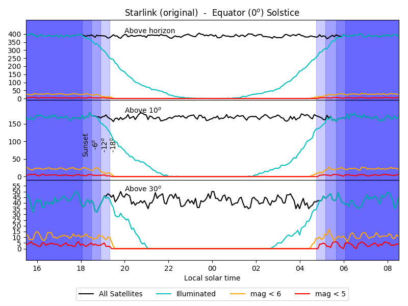 |
 |
| Starlink Revised (Apr.20) | 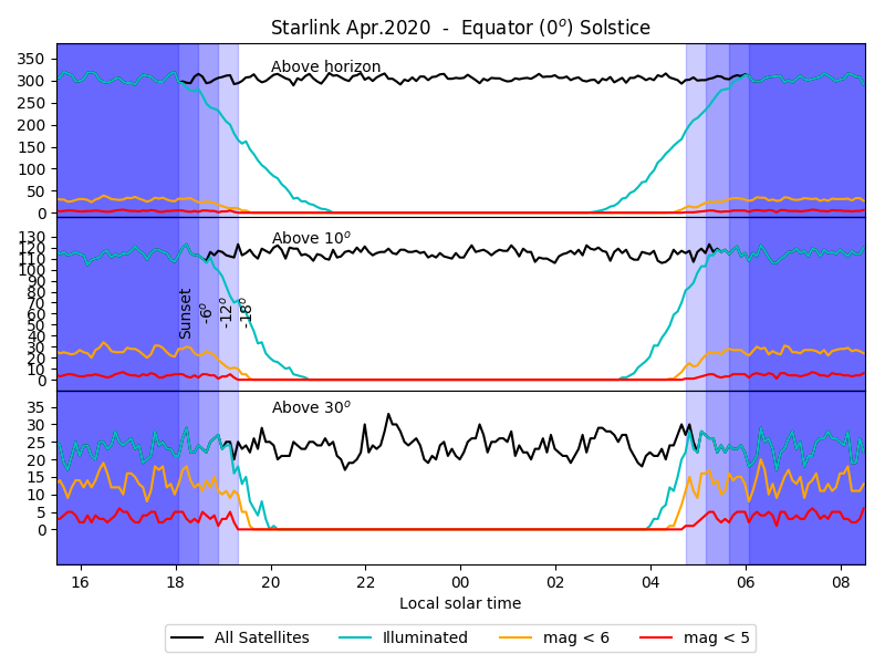 |
 |
| Starlink Gen 2 (Model III) |  |
 |
| OneWeb Ph.2 (Model IV) |  |
 |
| Paranal (25deg)
|
| Model | Summer | Equinox | Winter |
|---|
| Original Starlink (Model I) |  |
 |
 |
| Starlink Revised (Apr.20) | 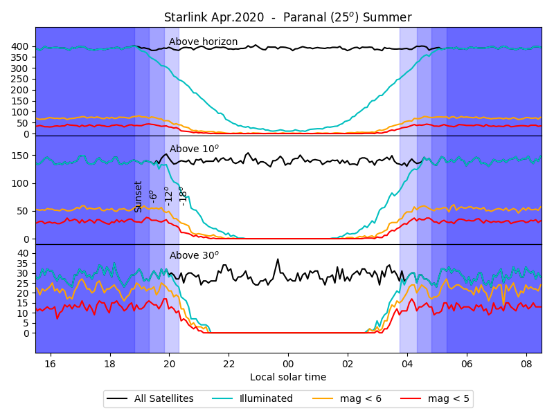 |
 |
 |
| Starlink Gen 2 (Model III) | 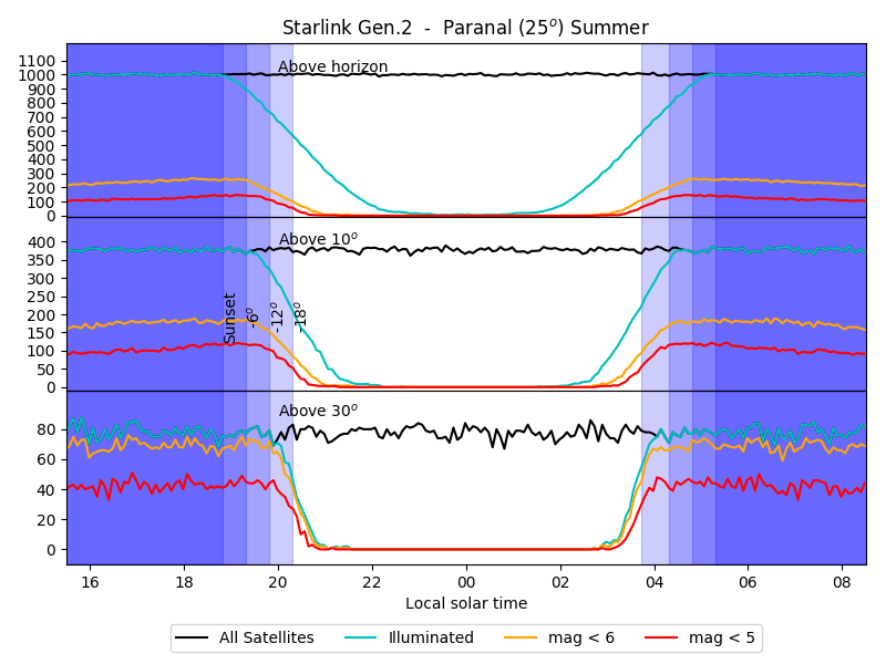 |
 |
 |
| OneWeb Ph.2 (Model IV) | 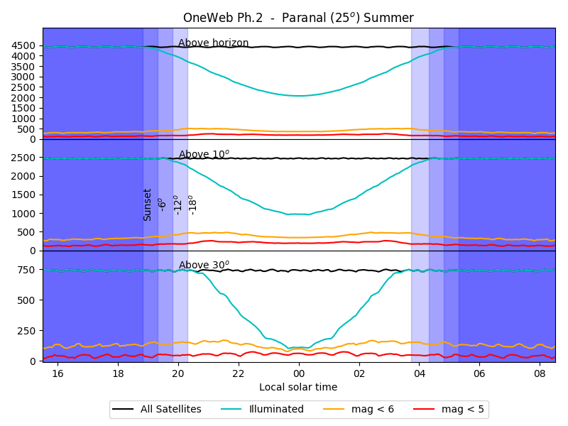 |
 |
 |
| Tololo (30deg)
|
| Model | Summer | Equinox | Winter |
|---|
| Original Starlink (Model I) | |
|
 |
| Starlink Revised (Apr.20) | 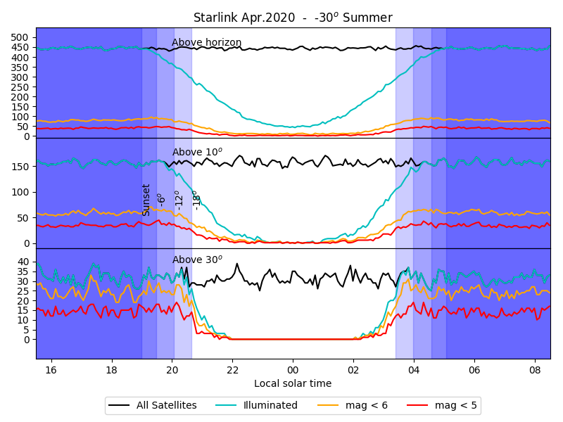 |
 |
 |
| Starlink Gen 2 (Model III) | 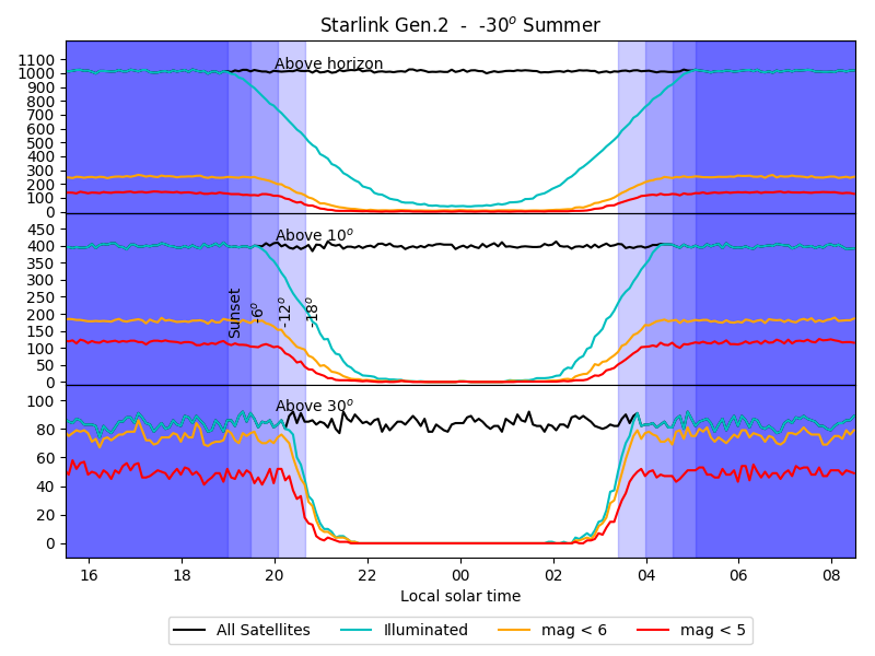 |
 |
 |
| OneWeb Ph.2 (Model IV) | 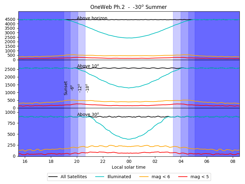 |
 |
 |
| Bruxelles (50deg)
|
| Model | Summer | Equinox | Winter |
|---|
| Original Starlink (Model I) | 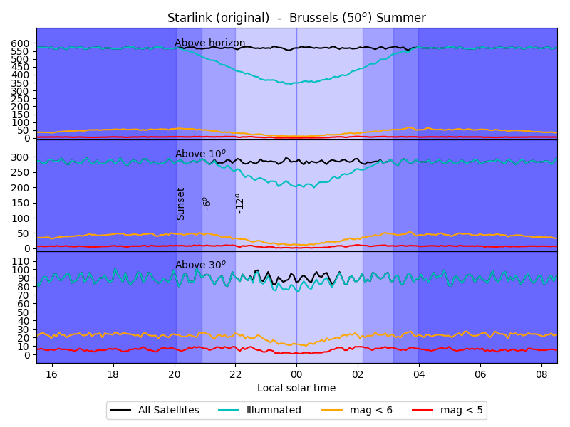 |
 |
 |
| Starlink Revised (Apr.20) | 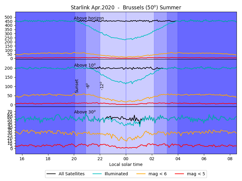 |
 |
 |
| Starlink Gen 2 (Model III) | 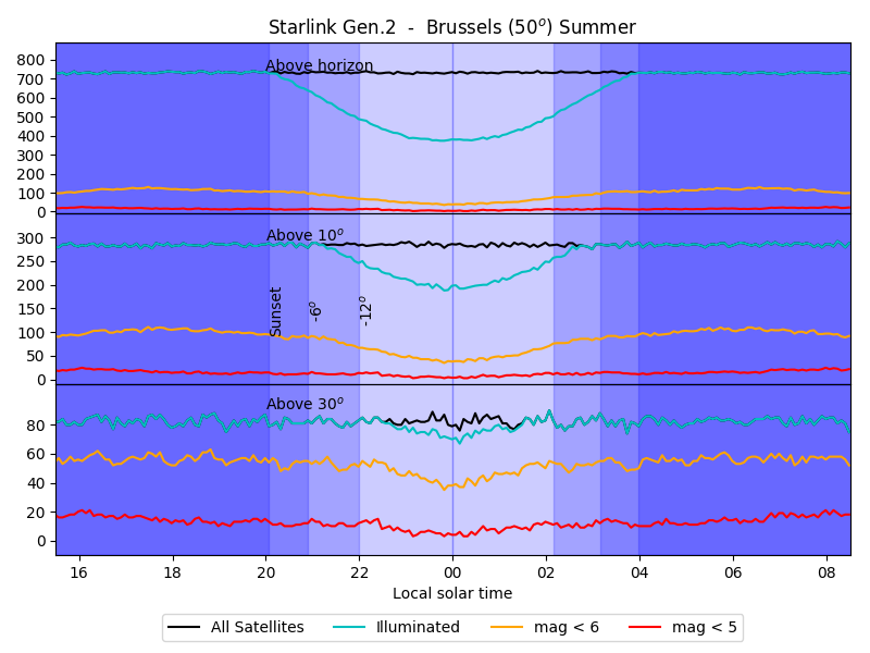 |
 |
 |
| OneWeb Ph.2 (Model IV) | 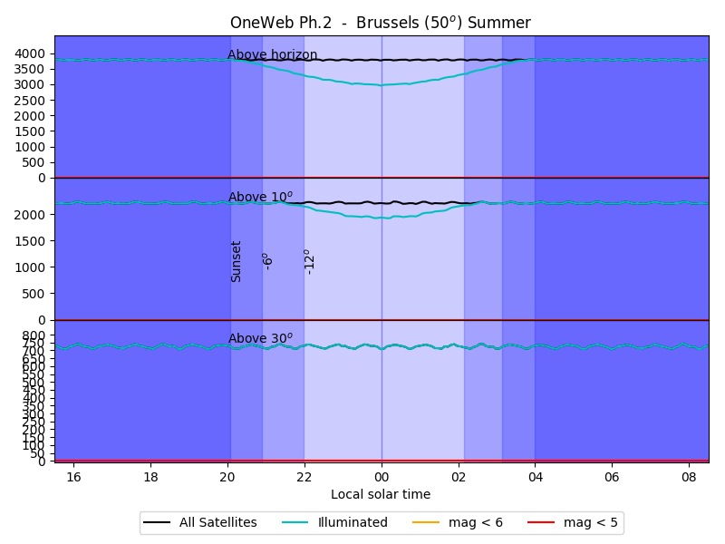 |
 |
 |