
![[Image - Ship discharging]](../img/sp_ship.jpg)
![[Image - ERS Satellite]](../img/erscraft.jpg)
Only a few countries in the world have a pollution control along their coasts and are patrolling regularly using ship or aircraft. A new way of monitoring our Seas is space, from an orbiting satellite, such as the ERS satellites built and launched by the European Space Agency. The ERS satellites have a Radar aboard able to watch the Earth's surface at all times, even through clouds and in the night. Radar-images look similar to photographs but their interpretation is different (see the Radar Mini-Tutorial).
![[Image - Ship discharging]](../img/sp_ship2.jpg)
![[Image - Oil-covered bird]](../img/bird.jpg)
Marine oil pollution is not only caused by accidents. Rather the biggest contributor to oil pollution in the World's oceans is operational discharges from tankers (i.e. oil dumped during cleaning operations). The amount of oil introduced in the sea by such operations is equivalent to one full-tanker disaster every week!
In a radar image the ocean is not blue but black and white and also has a lot of strange features. As a general rule, the brighter the sea surface the rougher the sea (the higher the wind speed). But oil on the water dampens the rough surface, so it becomes smooth again (and dark, as shown in the image below).
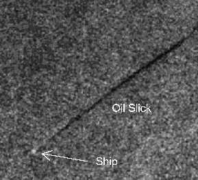
Ships appear as bright points. But what is this? A ship with a very long black trail behind? It is not merely a wake, but that ship is obviously washing its oil tanks. An operation that pollutes our seas and therefore is illegal, at least in the Mediterranean Sea.
And we are in the Mediterranean Sea, off the coast of France!!
This is the story. Early last spring, on a calm but misty day, the patrolling aircraft of the French Coast Guard observed a ship spilling oil. At 09.50 GMT (Greenwich Mean Time) they reported: Spilling ship in position: 7°12'E 42°14'N , spill is about 4000m long and 100 m large, and is of light oil, and has silver colour.
But at 10.17 GMT of the same day the ERS satellite passed as well. And now we want you to be the alert operator that analyses the satellite image and eventually give the French Coast Guard more evidence to confirm their observation. Especially, since from space a much larger view is possible.
From the image it seems that the spill is much longer than what the aircraft could see. The spill is interrupted, for one or another reason.
Here is the image. If your browser supports JAVA, the applet will give you precise coordinates and distances as you move the mouse.
![[Image - Ship discharging oil]](ex3.jpeg)
Well, thanks for your contribution! I think the Coast Guard have now enough evidence to prosecute the ship's captain. Next time that captain will think twice before discharging oil illegally at sea!