As described above - a precise comparison of the time of Local Noon in your place, and the time of Local Noon in Greenwich (the transit time) will allow you to determine your longitude.
However, for this you of course you need a precise timing method. Nowadays, this is easy, you just look at a watch which has been set to the correct time (for instance GMT or CES) by listening to the time signals on the telephone or the radio. This is a common process that is called time synchronization (from Greek: same time).
But imagine that there would be no telephone and no radio! Even though you may have a watch, how do you know that it is correct? This was the situation in earlier days!
What then? Indeed, this was a huge problem for our ancestors. Even though they had simple clocks, these could not be transported without loosing their accuracy, and certainly not on ships! So time synchronization was very difficult.
But the astronomers knew how to overcome this problem. Lunar eclipses - when the Moon enters into the Earth's shadow - can be seen from many places on the Earth. Two observers in different places will see it happen at the same time. Thus lunar eclipses provided one of the best old methods of world wide time "synchronization".
The very first efforts - by Ptolemeus and others - have been described in the EAAE Astronomy On-Line Lunar Eclipse Projects 1997.
A Lunar Eclipse in 1499 was applied for this by Amerigo de Vespuccio (who gave name to the continent). Comparing simultaneous observations from Venezuela and Cadiz (Spain), he was able to make the first correct determination of this continent's longitude. See here for additional details.
However, Lunar eclipses are relatively rare. There are typically only about 50 lunar eclipses during a life-time. Thus, lunar eclipses were not sufficiently to provide large-scale mapping of the Earth in the old days.
Another well-timed astronomical phenomenon, which could also be observed at the same time (simultaneously) from many sites on the Earth was needed for this.
For this reason, Galileo once suggested that sailors should observe the Moons of Jupiter (which he was the firtst to see by means of the new telescope), since these actually eclipse each other quite often (this is referred to as mutual events by astronomers). This would be a quite useful method for the measurement of longitudes, provided you had accurate tables of the times these moons were eclipsed.
It was during the preparation of such tables for sailors that Ole Roemer made his most significant discovery in 1676: the finite speed of light. If you want to know more about this, try to read the article in the EAAE Newsletter #3.
However, this particular method required a lot of skill, and was practically useless on a ship rolling on a stormy ocean. So, sailors needed another method of timing. The only proper method was of course a travel-resistant clock, which - once adjusted at home in Greenwich - could keep a correct time during long voyages at sea.
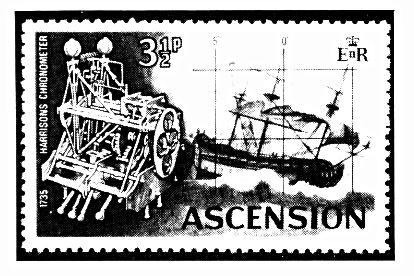
Such a most useful instrument was invented by a British watch maker, James Harrison, in 1735. Harrisons invention, a chronometer, was a most precise watch, and it kept the correct time, irrespective of the ship's movements - it even worked in stormy conditions.
 [JPG, 36k]
Stamp celebrating the first test of the Harrison Chronometer.
During a very stormy month-long voyage from London to Jamaica and back again to London (it was reported that "even the Captain became seasick" so it must have been really bad!), a watch of this type was found to keep its original time to within an error of only +/- 30 seconds!
Exercise: 24 hours (360°) correspond to the circumference of the Earth, that is 40 000 km. What distance (longitude) error would a timing error of +/- 30 seconds correspond to?
Now the British sailors had a most precise timing method, and they no longer needed any eclipses. In fact, Harrison's invention gave the British Admiralty the best chances of determining Local Noons and therefore accurate geographical longitudes. The longitudes thus measured by Sir James Cook in the second half of the 18th century resulted in the most precise World Maps ever made until that time.
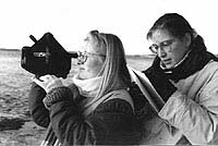
On this photo, you will see two students from the Soenderborg Amtsgymnasium (High School) in Denmark, using a sextant to measure the Sun's position in the sky. This instrument can measure angles in the sky and gives very accurate results, in particular if you include all sailor "extras" like refraction, altitude-correction, etc.. Before the advent of non-astronomical navigational methods like the GPS, the sextant was the main navigational instrument for all sailors. It was even used in the early days of flying, for instance during the first commercial flights over the polar regions in the late 1950's and early 1960's.
But remember, you do not need such sophisticated methods to participate in this project!
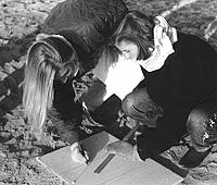
Another, much easier method, is simply to construct a gnomon and to use the simply methods described here. It need not be very large - see the photo below!